Yes, ladies and gentlemen -- we have yet another system in the tropics that has the potential of becoming the next named storm, which would be "Zeta."
Invest 95L has now developed into Tropical Depression 28 in the Caribbean and is moving slowly towards western Cuba this weekend, according to the National Hurricane Center.
TD 28 has maximum sustained winds of 30 mph and is heading north at 2 mph.
It should enter the Gulf of Mexico by Tuesday, but the good news, TD 28 is not expected to impact Texas in any way.
If it becomes a named system, 2020 will tie 2005 for the most named storms on record, which stands at 28.
Watches and Warnings for Tropical Depression 28
A Tropical Storm Watch is in effect for Pinar del Rio Cuba
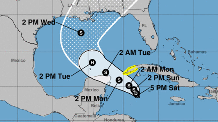
Outlook for Tropical Depression 28
At 400 PM (2100 UTC), the center of Tropical Depression Twenty-Eight was located near latitude 18.7 North, longitude 83.0 West. The depression is moving toward the north-northwest near 2 mph (4 km/h), and this motion is expected to continue through early Sunday. The system should gradually turn toward the west-northwest with a faster forward speed by Monday. On the forecast track, the center of the depression is anticipated to remain south of Cuba tomorrow and approach the Yucatan Channel or Yucatan Peninsula late Monday before emerging into the southern Gulf of Mexico on Tuesday.
Maximum sustained winds are near 30 mph (45 km/h) with higher gusts. Slow strengthening is forecast during the next 72 hours, and the system is expected to become a tropical storm on Sunday and could become a hurricane over the southern Gulf of Mexico on Tuesday.
The estimated minimum central pressure based on NOAA Hurricane Hunter aircraft data is 1005 mb (29.68 inches).
Key Message for Tropical Depression 28
1. The depression is forecast to strengthen to a tropical storm Sunday and could bring tropical storm conditions to extreme western Cuba on Monday, where a Tropical Storm Watch is in effect. There is also a risk of tropical storm conditions in the northern Yucatan Peninsula of Mexico Monday night and Tuesday.
2. Through Wednesday, heavy rainfall is expected across portions of central and western Cuba, the Cayman Islands, Jamaica, the northeast Yucatan peninsula of Mexico, southern Florida and the Keys. This rainfall may lead to flash flooding in urban areas.
3. The system is forecast to approach the northern Gulf Coast as a tropical storm on Wednesday, and could bring storm surge, rainfall, and wind impacts to areas from Louisiana to the Florida Panhandle. Residents in these areas should monitor the progress of the depression and updates to the forecast.
Hurricane Epsilon
Hurricane Epsilon has weakened to a Cat 1 with 75 mph winds and higher gusts. This weekend it is expected to move into the North Atlantic.
Epsilon is forecast to become a large and powerful post-tropical cyclone early next week.
The good news, Epsilon is not expected to impact the U.S. in any way.